If you love mountain biking like I do, you probably know how easy it is to get turned around on the trails, even if you’ve ridden them before. Trail networks can feel like a maze, signs sometimes go missing, and making a wrong turn can change a fun ride into a frustrating one. That’s at the heart of why modern smart navigation devices are making such a difference for riders like me. In this article, I’ll share how these tools are helping clear up trail confusion and making mountain biking more enjoyable for everyone, from beginners to experts.
Why Getting Lost Happens So Often on Mountain Bike Trails
Even seasoned mountain bikers sometimes get off track, especially at bigger trail networks or when exploring unfamiliar spots. Trails might crisscross, fork out of nowhere, or change names suddenly. Sometimes, environmental factors like fallen trees block the path, while weather or faded markers make finding the right way even harder.
I’ve ended up on rides where everything looked simple on the trailhead map, but connections and forks weren’t actually marked along the way. Regular maps and basic apps usually won’t reveal those last-minute changes, which makes missing turns easy. If you’re doing a loop ride, remembering which direction to go at every intersection gets surprisingly tricky, especially after a few hours on the bike.
How Smart Navigation Devices Work for Mountain Bikers
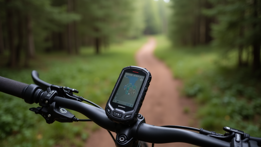
These days, smart navigation devices combine GPS tech, frequently updated maps, and special mountain biking features to keep you on track. Most attach right to your handlebars, so directions stay visible as you ride. Devices like the Garmin Edge series, Wahoo ELEMNT, or even sturdy smartphones loaded with trail-specific apps are changing the game by offering step-by-step guidance.
Here’s how these devices help out:
- GPS Tracking: Real-time GPS shows your precise position, which means you can track both where you’ve gone and exactly where each trail junction in front of you leads. No more guessing.
- Trail Maps: Many now support dynamic mapping with overlays from Trail forks or OpenStreetMap, meaning your maps get regular updates as trails switch around.
- Route Planning: Before I head out, I map out my ride and then get notified before each turn. That way, second-guessing at every intersection becomes a thing of the past.
- Points of Interest and Alerts: Most apps let you pin cool features like river crossings or technical zones, while push alerts warn you of big climbs or steep drops coming up.
Getting Started With Your First Navigation Device
Trying out a smart navigation device today is way easier than it used to be. If you’re just jumping into bike tech, free apps like Trailforks, Komoot, or Ride with GPS all run on your phone and let you try out digital navigation basically risk-free. Just mount your phone to your bars with an inexpensive holder and you’re good to go.
For those riding often or in tougher terrain, dedicated bike computers from Garmin and Wahoo offer more resilience against rough conditions like mud or rain. They also hold a charge longer than most smartphones and provide clearer screens in bright sunlight. With features like touchscreens or easy-to-use physical buttons (great for gloved hands), these computers are built for mountain biking’s demands.
- Choose Based on Your Riding Style: A short day trip at a familiar park? A smartphone app will serve you well. Into longer, more remote rides? Consider a dedicated device that can handle offline maps and offers a robust GPS signal for the backcountry.
- Sync With Popular Trail Apps: You can easily upload routes from platforms like Trailforks, Strava, or MTB Project. Planning and sharing rides has never been smoother.
Common Challenges and How Smart Devices Help
While tech isn’t perfect, smart navigation gadgets handle several common headaches for mountain bikers:
- Dead Zones and Battery Life: Plenty of trails have no cell coverage, but you can download offline maps to most gadgets and apps. For really long rides, packing a power bank keeps your device charged and ready.
- Changing Trail Networks: Some centers reroute paths due to erosion or private property updates. Devices connected to community-driven map updates show you the latest info, so you sidestep dead ends and surprises.
- Tricky Terrain: On sketchy descents or muddy bits, stopping to check a paper map is the last thing you want. Turn prompts and a quick at-a-glance route keep your attention on the trail while still giving you direction.
- Weather Surprises: Rain, fog, or fast-fading daylight can hide trail markers. Bright-screened devices and bold on-screen warnings mean I can rely on technology instead of hoping to spot faded paint or old signs.
GPS Signal Loss
Heavy forests, deep valleys, or thick storm clouds can knock out satellite signals for a bit. I’ve learned to keep riding steadily and give it a moment to reconnect; most devices restore signal automatically. Bike computers using multiband satellite reception usually outperform phones in these tough spots.
Keeping the Device Secure
Bumpy drops or chunky ground can shake mounts loose if you’re not careful. Using quality mounting systems and doing a gear check before every ride helps keep everything attached, even when things get rowdy.
Features I Find Really Useful on the Trail
- Turn-by-Turn Directions: Knowing about upcoming turns keeps me from missing exits, so I don’t waste time backtracking and can push ahead confidently.
- Live Elevation Profiles: Seeing how much climbing or descending is ahead lets me pace myself and save my legs for the tough spots.
- Trail Conditions and Community Updates: Some units pull real-time updates from local riders about muddy stretches or blocked trails, giving me a jump on changing conditions.
- Route Recording and Sharing: Saving my ride means I can look back on it, share new trail finds with friends, or even retrace my steps if I lose the route.
Advanced Tips to Get the Most Out of Your Device
With experience, I’ve found some helpful tricks to maximize my smart navigation gear:
- Pre-Download Maps: Before exploring somewhere remote, I make sure detailed offline maps are saved, so losing signal isn’t a worry.
- Custom Alerts: Setting up audio or visual cues for steep climbs, gnarly features, or meeting spots means I don’t have to keep looking down.
- Connect to Sensors: Pairing bike computers with cadence or heart rate sensors helps me dial in my effort, especially on long adventures or when training.
- Plan Bail-Out Spots: Always build in shortcuts or easy exit routes in your plan—if the weather changes or you need to call it early, you’re covered.
Gear Suggestions for Beginners
If you’re new to this, here are some simple gear picks that make smart navigation work even better:
- Handlebar Phone Mount: Affordable and a great starting point if you already use a nav app on your phone.
- Rugged GPS Bike Computer: Lightweight, water resistant, and made for repeated use—worth the investment if mountain biking is your go-to.
- Portable Power Bank: For all-day rides, cold days, or someone who also likes to take trail photos, an extra charge is key.
- Protective Case: Keep your phone or device safe from drops, rain, and dirt with a tough, waterproof case.
Frequently Asked Questions
Question: Are smart navigation devices hard to use while riding?
Answer: Most have clearly visible, bright screens and are made with user friendly controls that work with gloved hands. After a couple of rides, following on-screen prompts becomes second nature without any stops.
Question: Do I need an expensive GPS unit for my local trails?
Answer: For most casual riders, a well-designed phone app is plenty sufficient. If you start venturing into larger systems, join group rides, or explore new areas, dedicated computers offer more dependability and advanced options.
Question: How do I make sure my device map is up-to-date?
Answer: Syncing your app or device to Wi-Fi or plugging in to a computer on a regular basis keeps maps fresh. Most trail apps update themselves thanks to super active riding communities reporting trail closures or reroutes.
Wrapping Up
Smart navigation devices really put the fun back into trail riding for both me and many other mountain bikers. They remove the uncertainty, keep detours to a minimum, and let everyone enjoy the ride without distractions. Whether you’re just testing the waters with mountain biking or taking on tough backcountry trails, these tools can give you a confidence boost and help you stumble upon new rides you’ll love. Keeping your maps current and picking features that match your ride style make a big difference in how you experience the outdoors. Time to hit the trails!